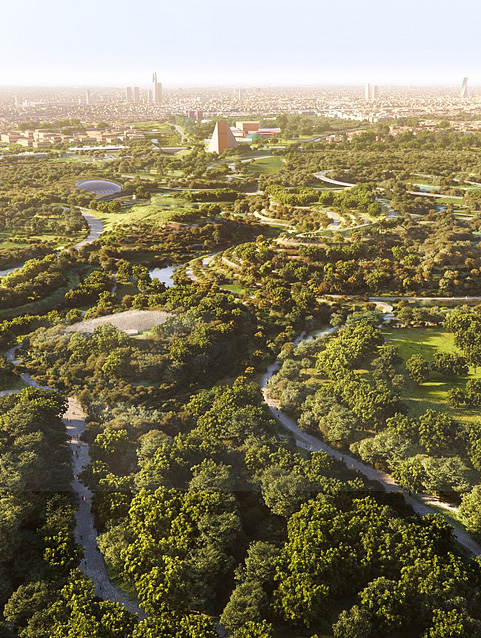
The Royal Commission for Riyadh City gave priority to preserve and rehabilitate Wadi Hanifah (Hanifah Valley) due to its strategic location, investment capabilities, and potential to serve as urban lungs for the city and its residents.
Located in the middle of Najd Plateau, Wadi Hanifah is the most significant natural landmark of the region that form with its basin and tributaries a unique 120-kilometer long ecological region stretching from Tuwaiq Escarpment to the open desert southeast of Riyadh. The depth of valley stream ranges between 10 and 100 meters, and its width ranges from 100 to 1000 meters approximately.
Wadi Hanifah represents a natural watershed for the floods and rainwater in an area of 4000 m²and it has more than 40 tributaries. The most important among thevalley’s tributaries are Al-Obaitah, Al-Imariyah, Safar, Al-Mahdiyah, Beir, Laban, Namar, Al-Awsat and Laha in the west, and Al-Aysan and Al-Bathaa in the east. The amount of water poured into Wadi Hanifah is about 700,000 m³.
The valley has five sections including bed, floodplain, horizontal alluvial terraces, valleys and branches. Many small and large villages scatter along the banks of the valley. The locals there work in agriculture and own arboretums, palm gardens, and farms where they plant grains, vegetables and fruits. In addition, the valley is the home of many historic and ancient buildings, wells and dams.
From the early 1970’s, Riyadh expanded westward towards Wadi Hanifah, eventually spreading along its west bank. The valley was utilized to satisfy the increasing demand for water, mineral resources and construction aggregates arising from the rapid growth of the City. By the 1980’s, water resources in the valley and in the Region could not cope with the demand, and water table levels were dropped well below sustainable limits.
The valley provided a convenient and substantial source of stone and aggregates for construction, but mining and excavation activities severely damaged the valley’s landforms. Uncontrolled dumping of the industrial, clinical and domestic waste meant that there is a risk of groundwater and surface water contamination.
The negative impacts of these activities on environmental balance of the valley also included serious deterioration of its topographies and soil formations.
To stop the deterioration of the valley’s environment, the Royal Commission for Riyadh City decided, in its third meeting in 1408H (1987), declaring the valley as an environmental reserve and a development area under its direct supervision. Later, the RCRC’s second meeting in 1415H (1994) witnessed adoption of a comprehensive rehabilitation plan for the valley and its tributaries featuring a number of policies and measures to stop the valley environmental deterioration through removal of disorderly activities and uses, in addition to achievement of the following objectives:
In 1423H (2002), the Royal Commission for Riyadh City approved Wadi Hanifah Comprehensive Development Plan to be the master plan for all the current and future human activities that include water resources management, environmental classification and land uses.
Wadi Hanifah Environmental Rehabilitation Project represents the foundation of all subsequent development projects, as it aims to achieve two core objectives:
The works include refinement of watersheds and dividing them into three levels. The first was the flowing water level fed by the city groundwater and flood drainage networks. To achieve this, an open fresh water channel was established and supported with rocky formations and other equipment to process water and maintain drainage abilities throughout the year. This channel is 57-kilometer long and its width reaches about six meters in some parts, while its depth is 1.5 meters.
The second was the seasonal flood level (used only during the rainy seasons). The valley bed was leveled obliquely to the south and laterally towards the permanent channel. The valley brinks were supported at some critical points to consolidate the valley bed and enable it withstand floodwater.
The third was the flood level; given its rare use (flood occurs every 50 years), the preparations mainly focused on prevention of any violations to the flood streams and cleaning the valley’s bed and tributaries.
This system is designed to create balance between functional requirements of the project and the strict environmental criteria set out by the valley’s Comprehensive Development Plan. The environmental rehabilitation plan adopted a new natural and non-chemical water treatment system that can provide suitable environment for the micro creatures, which feed on the organic and non-organic components in the water.
This system allows to reuse treated drained water into the valley every year for various agricultural, industrial and urban uses.
The valley’s bed was chosen to establish a bioremediation facility over an area of more than 100,000 m²to provide sufficient levels of dissolved oxygen (DO) to the system which kills coliform bacteria and create favorable conditions to microbes, fish and other aquatic organisms. The facility also has 140 bio-cells, which are 30 meters long and two meters deep, and electric aeration system to improve the treatment process. The system was chosen specifically given its low operational cost and natural mechanism that blends with the valley environment.
The main achievements of the bioremediation facility include:
The project included rearrangement of the public facilities adjacent to the revitalized valley to blend with its sensitive environment by transforming the existing aerial lines to ground in coordination with the concerned authorities. It also included setting an area along the valley to serve as passageway for all local service lines that cross through the valley according to certain specifications and based on detailed maps. Also, this applied to drinking water networks, power grids, and landline phones.
A new 43-kilometer roadway extending from the north at Elab Dam, Diriyah, to Al-MansouriyaRoad was built. The road’s width ranges between 6 and 9 meters and is located along the valley side parallel to the service passageway and far from the valley center as a precautionary measure to protect it from floods. About 22 bridges and crossings were established at the intersections between the road and the channel. The road was equipped with more than 730 instructional and warning signs to guide and brief the visitors and drivers about the valley’s natural and historic landmarks as well as services.
The works to improve the valley road network also include lighting of roads and walkways using 2500 lampposts, in addition to 600 lighting units for the bridges and other parts of the valley. Additionally, new parking lots were established on the roadsides to accommodate more than 2000 cars and certain locations were prepared to host kiosks and trash containers.
The valley pedestrian walkways extend for 47 kilometers in the most beautiful locations overlooking the valley, in addition to 7.4 kilometers of pathways paved with rocks near magnificent rock formations, green areas and streams. The walkways are paved specifically to facilitate walking and movement of pushchairs and wheelchairs, and they are also equipped with seats and rest areas.
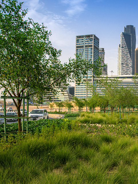
In order to restore the valley’s natural plant cover, Wadi Hanifah Environmental Rehabilitation Project relied on cultivation of the plants that usually grow up in the area, and afforestation that is sustainable depending on valleys surface water and groundwater resources.
Accordingly, 30,000 desert trees and 7000 palms were planted in the valley’s bed, in addition to 2,000 other desert trees including acacia, acacia tortilis and Salam. Moreover, about 50,000 small trees were also planted using seeds and seedlings.
Beside rehabilitation of the valley bed, Wadi Hanifah Environmental Rehabilitation Project comprised establishment of the following six open parks:
The Royal Commission for Riyadh City developed a bundle of architectural regulations to guide the development of the valley’s historic locations, to preserve its architectural characteristics, and to develop it culturally, environmentally and socially. The regulations would also govern the process of connecting the valley to the neighboring districts, protect its historic locations, and highlight its historic and architectural characteristics.
In line with the aforementioned strategy, the project set out certain specifications for fences of the private farms, particularly the parts visible to the visitors of the valley and the parts overlooking it, to achieve harmony between the valley’s natural elements. These specifications were developed in accordance with the general requirements and technical details. It include that the fences must be within the borders stated in the title deed, taking into consideration the elevation difference between the adjacent farms. Additionally, all internal fences and the ones overlooking the valley must be covered with Riyadh Stone using homogeneous materials with specific measurements. The specifications also include flood openings beneath the walls to allow unobstructed passage of water.
Through these measures, the Royal Commission for Riyadh City aspires in preserving the traditional architecture of the valley, and stressing the role of the local farm owners and citizens in preserving this architectural heritage.
The RCRC developed a set of environmental regulations to ensure the sustainable and healthy environmental preservation in Wadi Hanifah in addition to continuous monitoring of the water, air and soil pollution indicators.
The Royal Commission for Riyadh City established GIS database for Wadi Hanifah and Environmental Information to facilitate access of different environmental studies conducted by the RCRC on the valley in particular, and the city in general. This database is expected to significantly support the environmental decisions and boost monitoring of the changes and violations thanks to the world’s latest GIS and database systems.
Like many other projects carried out by the RCRC, Wadi Hanifah Environmental Rehabilitation Project won several renowned international awards including:
Aga Khan Award for Architecture, 2010. According to the award-granting foundation, “The Award has been given in recognition of the project’s vision and persistence in developing a sustainable environment. Using landscape as an ecological infrastructure, the project has restored and enhanced the natural systems’ capacity to provide multiple services, including cleaning the contaminated water, mediating the natural forces of flood, providing habitats for biodiversity and creating opportunities for recreational, educational and aesthetic experiences.”
Wadi Hanifah Rehabilitation Project was inaugurated on Monday, 20 Rabee’ II, 1431H (5 April, 2010) under the patronage of King Salman Bin Abdulaziz, who was at this time the chairman of the RCRC. He also opened seven sites within the project, including open parks, surface water bioremediation station and some lakes.
Wadi Namar, south of Riyadh, stretches from west to east until meeting Wadi Hanifah in Utaiqah. The first stage of Wadi Namar Environmental Rehabilitation Project covered the course of the valley from Wadi Namar Dam Lake until meeting Wadi Hanifah in Utaiqah District.
Wadi Namar rehabilitation project included refinement of flood streams and other works necessary to provide the project with infrastructure and services such as local routes, lighting network, a corniche overlooking the lake dam, guidance system, and improved traffic management system to serve local farm owners and hikers. Additionally, the project included afforestation using palm trees and local plants, and landscaping of sidewalks and walkways.
The project also included the following:
Local traffic is the main focus of the valley traffic plan. The valley road network was designed specifically to alleviate flood-related hazards and its rocky edges prevent vehicles from slipping into the bed of the valley. The 6-km local road in Wadi Namar is equipped with traffic signs, traffic calming devices, and parking areas on both sides that can accommodate about 800 vehicles.
Stone dust walkways, totaling 892 meters in length, were built across the rocky formations and green areas near the water channel. The pedestrian walkways are prepared for walking sport, while the parallel sidewalk is used as a service passageway.
Roads and pedestrian walkways were lit in a way consistent with the valley nature and environment. About 245 lampposts were installed at all open areas and across the valley.
Wadi Namar underwent an extensive rehabilitation process aiming at restoration of its green cover. Therefore, the valley was provided with more than 520 palms planted across the pedestrian walkway, while the heart of the valley received more than 9500 different trees.
Afforestation was conducted according to the recognized scientific standards to guarantee sustainability and meet the area’s environmental and climate requirements. The selected trees originally grow under the desert climate and they are supported by a 1600-meter irrigation system used during drought seasons.
The Namar Dam Lake is 2 kilometers long, 170 meters wide, and 20 meters deep. The lake’s total area is 200,000 m²representing one of the area’s fascinating attractions, in addition to its role in deodorization and refreshment of the fungal life in the park and the surrounding area.
Additionally, a new 3100-meter rocky permanent water channel (8 meters wide and 1.5 meters deep) was established to connect the area from Namar Dam to the estuary at Wadi Hanifah.
The 2-km corniche extends along the walkways overlooking the lake dam and it is equipped with palms and public utilities. The corniche also has special areas, where pedestrians and picnickers can sit to enjoy the view of the lake, and entrances that allow visitors to move between ends of the lake and the corniche.
Wadi Laban stretches from west to east until meeting with Wadi Hanifah at Al-Qurashiyah. The first stage of Wadi Laban Environmental Rehabilitation Project covered the area between Wadi Laban Dam and Wadi Hanifah and included cleaning the valley bed and the basin of its dam, in addition to refining streams. The first stage also included construction and lighting of road network to facilitate traffic that would only serve hikers and local farm owners. A service passageway, landscaped areas, afforestation, and rest areas were also included in this stage.
The project also included the following works:
Wadi Laban traffic plan solely focuses on the local traffic, which serves the locals and picnickers. The valley road network was designed specifically to alleviate flood-related hazards and its rocky edges prevents vehicles from slipping into the valley bed. The 3800-meter local road in Wadi Laban is equipped with traffic signs and safety devices, in addition to parking areas that can accommodate about 328 vehicles.
The roads and pedestrian walkways were lit in a way consistent with the local environment. About 126 lampposts were installed and powered by an on-site power station.
Stone dust walkways, totaling 4300 meters in length, were stretched across the favorite destinations for the picnickers like the rock formations and green areas. On the other side, the 2800-m²walkway, which is parallel to the road, was used as a pedestrian passageway.
Wadi Laban was afforested using more than 100 palms planted along the pedestrian walkway, and more than 1500 different trees in the heart of the valley.
The afforestation process followed a long-term program to guarantee recovery of the valley’s natural green cover through selecting trees that can survive the desert climate.
About 30 locations overlooking the basin of Wadi Laban Dam were equipped with rock seats to serve the hikers and picnickers.
HRH Prince Sattam Bin Abdulaziz Al Saud, may Allah have mercy on him, inaugurated the first stage of Wadi Namar and Wadi Laban projects and opened Wadi Namar Park and Wadi Laban Park on Tuesday 18, Jumada Al-Ula, 1433H (10 April, 2012) .
Wadi Al Mahdia Environmental Rehabilitation Program, west of Riyadh, features a new a five-kilometer-long local road, 135 parking spaces, 1.2-km long pedestrian walkways, 4000 new trees planted, in addition to lighting and landscaping works.
Wadi Obeir Environmental Rehabilitation Program is adjacent to the Wadi Al Mahdia, west of Riyadh, and features a new 6.5-kilometer-long local road, 240 parking spaces, 2.5-km long pedestrian paths, 60 seating areas, 4,000 new trees planted, in addition to lighting and landscaping works.
Wadi Al-Batha Environmental Rehabilitation Program features a new 5-kilometer-long local road, 450 parking spaces, 7-km pedestrian walkways, 42 seating areas, in addition to lighting and afforestation works. Also, a 2-km section along Wadi Al-Batha stream was improved as part of the project.
The Royal Commission for Riyadh City carried out the Wadi Namar Lakeside Park project
over an area of 260,000 m2. It features a new 2.5-km long road, 500 parking spaces, 4-km pedestrian walkways, 140 seating areas, 4 plazas for different sports games, two kids play areas, 4 public toilets, over new 5,000 trees planted, in addition to lighting and landscaping works.
The project also features a waterfall running from the top of the valley to Namar Dam Lake, with a flow rate of 400 liters of water per second.